Symbols and colours help make maps easy to read and understand. Here’s why they are important:
- Save Space – Instead of long descriptions, symbols show things like roads, rivers, and mountains clearly.
- Quick Understanding – Colours help tell different features apart. For example:
- Blue → Water (rivers, lakes, seas)
- Green → Forests and vegetation
- Brown → Mountains and hills
- Black → Roads and buildings
- Red → Highways and important places
- Universal Use – Many symbols are the same worldwide, so people can understand maps easily.
- Better Navigation – Helps in travel, planning, and finding locations quickly.
Additional facts
1. Symbols Are Universal
- Many map symbols follow international standards, so they can be understood worldwide.
- For example, an airplane symbol represents an airport, and a tent symbol represents a campsite.
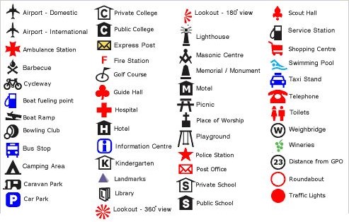
2. Different Types of Symbols
- Point Symbols → Show small locations like cities, temples, or wells.
- Line Symbols → Represent roads, railways, rivers, and borders.
- Area Symbols → Indicate forests, lakes, deserts, or mountains.
3. Different Maps Use Different Colours
- Political Maps → Use different colours to show countries, states, or districts.
- Physical Maps → Show landforms using colours like green for plains and brown for mountains.
- Weather Maps → Use colours to show temperature, rainfall, and storms.
4. Red and Black Are Used for Important Features
- Red is used for main roads, highways, and important places.
- Black is used for boundaries, railway lines, and buildings.
5. Maps Help in Everyday Life
- Used in Google Maps, GPS navigation, travel planning, disaster management, and city planning.
- Without symbols and colours, maps would be confusing and difficult to read.
FAQs
Maps use symbols to save space and make information easier to understand. Instead of writing long descriptions, simple icons or colours represent features like roads, rivers, mountains, and buildings.
Colours help differentiate features:
► Blue → Water bodies (rivers, lakes, seas)
► Green → Forests, vegetation, and lowlands
► Brown → Mountains and hills
► Black → Man-made structures (roads, railways, boundaries)
► Red → Highways, main roads, and important places
Most maps use standardized symbols that are understood worldwide, like an airplane for airports or a tree for forests. However, some maps may have unique symbols, so they often include a legend (key) to explain them.
A legend (key) explains the meaning of symbols and colours used on a map. It helps readers understand what each symbol represents, making the map easier to use.
Symbols and colours make it easy to identify roads, landmarks, and natural features, helping people navigate cities, highways, and hiking trails efficiently.